Bust-up over Hackney ward boundaries

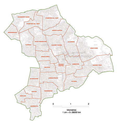
Changes: the proposed new wards and boundaries for the borough. Ordnance Survey Mapping © Crown Copyright Media 070/12
Draft proposals for a new administrative map of Hackney have been released amid allegations that the council supplied incorrect figures to an official review body.
Hackney’s ward boundaries need to be redrawn in advance of the next local council elections in 2014, and the council is currently consulting on the matter.
The existing wards, which date from 2002, are being reviewed by the Local Government Boundary Commission for England, the independent body in charge of local government boundary delimitation.
Under the new proposals, there will be 22 wards, up from the current 19, though nine of the new administrative areas will have two rather than three councillors, so the total size of the council will remain the same at 57.
If the proposals are adopted, the biggest shake-up will in the north of the borough. The plans call for the creation of four new wards: Woodberry Down, Stamford Hill West, Stamford Hill East and Upper Clapton. Brownswood ward will be reduced in size, whereas Clissold and Stoke Newington wards are to be expanded northward.
The other big changes are those proposed for the south-west of the borough, where the current trio of de Beauvoir, Haggerston and Hoxton wards are to be replaced with smaller versions of all three plus new wards to be called Wenlock and Shoreditch on the City borders.
Elsewhere Dalston ward would be divided into two: Dalston and Shacklewell, as well the renaming of Queensbridge ward to London Fields, and Chatham to Homerton.
The proposed two-member wards include: Brownswood, Dalston, De Beauvoir, Hackney Central, Hoxton, Shoreditch, Stamford Hill West, Wenlock and Woodberry Down . The remaining 13 wards are to retain three members.
The main parties in the borough disagree on the proposals. Cllr Rick Muir, Chair of Labour Group on Hackney council said: “The majority of the new ward proposals for Hackney are based on a council submission that Labour Group supported.
“We think the proposed boundaries do create more equal electorate sizes and the overall pattern looks like it more accurately reflects local communities than the current wards, but we are looking at the detail carefully.”
However, the Conservative party disputes the figures for projected population changes on which the revised boundaries are based. They maintain that because the north of Hackney has a very high birth-rate, it is anomalous that the proposals should reduce the number of councillors representing this part of the borough from 15 to 12.
Conservative councillor Simche Steinberger said: “We believe that if the Commission had been given accurate figures, they wouldn’t have drawn the boundaries they did. We believe they have misunderstood ‘community’, and we believe they have under-counted Springfield, New River, Lordship, Cazenove and de Beauvoir wards”.
The Commission’s report acknowledges that the figures provided to them by the council were problematic: “We noted that there appeared to be some discrepancies between the forecasts supplied by the borough at polling district level and the forecasts set out in its submission on new ward boundaries.
“We sought clarification from the Council with respect to these discrepancies. The Council subsequently resubmitted its forecasts, although some inconsistencies remain.”
The solution adopted by the commission is to refer “only to the polling district level forecasts prepared by the Council in analyzing submissions received and developing our own proposals.”
A Hackney Council spokesperson said: “Throughout this process Hackney Council has worked with the Local Government Boundary Commission for England and has provided data as requested.
“Due to the nature of forecasting in detail for small geographical areas it is difficult to attain a high degree of accuracy which can lead to some discrepancies in forecasting. This has been dealt with in the review and is reflected in the draft proposals which are currently open to consultation.”
A review of the borough’s 19 administrative areas began in January 2012 following changes in the number of people on the electoral register.
The new boundaries will have to be formally approved by Parliamentary before they come into force at the time of the council elections scheduled for May 2014.
The review has been triggered by the fact that at least 30% of Hackney’s current wards vary by more than 10% in the number of eligible voters they contain. When this criterion is met, a review is automatically called.
The current consultation closes on 24 September. To have your say, visit: www.lgbce.org.uk/all-reviews/south-east/greater-london/hackney-fer
Update 6.15pm Wednesday 12 September 2012: this story was updated to include a comment from Hackney Council which had previously been omitted.
